See what LandLens™ can do
A walkthrough of the planning constraint map and developer API — the two core tools that give property professionals instant access to planning intelligence for any UK postcode.
The Constraint Map
Interactive planning intelligence for any UK postcode

What it does
The constraint map is the heart of LandLens. Enter any UK postcode and instantly see every planning constraint that affects that site — flood zones, conservation areas, green belt, listed buildings, Article 4 directions, brownfield designations, and more. All data is sourced live from official government APIs, not cached downloads.
Each constraint layer renders as a colour-coded polygon overlay on the map, with a structured results panel showing what applies, what doesn’t, and the source of every data point. You can toggle layers individually, adjust the map view, and export the entire assessment as a branded PDF.
How it works
Enter a postcode
Type any UK postcode into the search bar. The map centres on the location instantly.
Toggle data layers
Switch on the layers you need — flood zones, conservation areas, green belt, listed buildings, and more. Each layer renders as a colour-coded overlay.
Review constraints
The constraint panel shows every active designation for that location — with source data, distances, and severity ratings.
Export a report
Download a branded PDF site report with all constraints, map screenshot, and data citations — ready to attach to a client email or board pack.

14 data layers included
The old way vs LandLens
Without LandLens
- ✗ Open 6–8 separate government portals
- ✗ Manually cross-reference each dataset
- ✗ 30–45 minutes per site assessment
- ✗ Risk of missing a constraint
With LandLens
- One search, all 14 layers at once
- Results in under 10 seconds
- Exportable branded PDF report
- Every data source cited
The Developer API
Programmatic access to UK planning data via REST endpoints
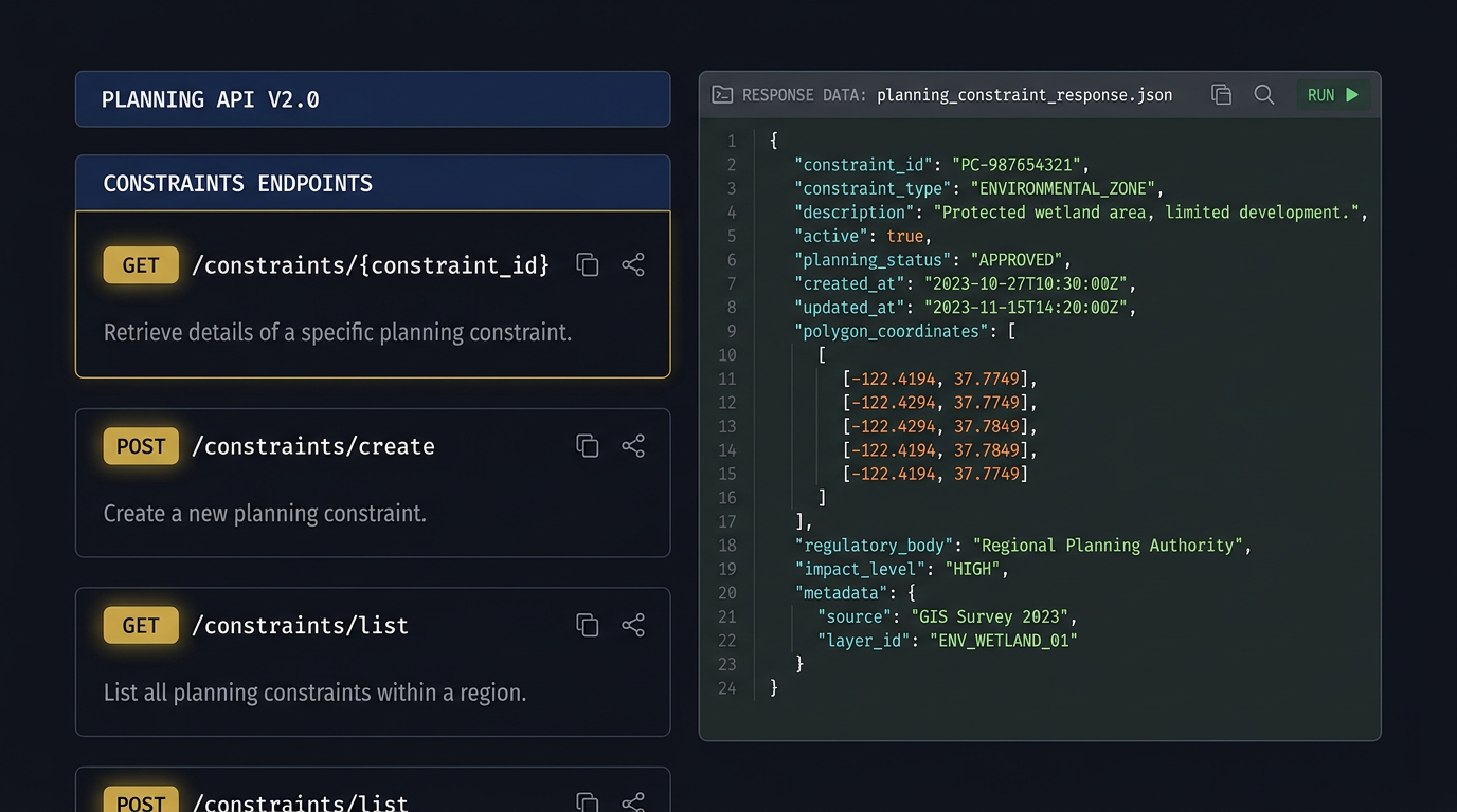
What it does
The LandLens REST API gives you programmatic access to every dataset available on the platform. Query planning constraints, flood zones, EPC data, price paid records, corporate ownership, and planning applications — all authenticated with dedicated API keys, rate-limited per key, with full usage analytics in your admin dashboard.
Build integrations into your existing tools, automate portfolio screening, power internal dashboards, or feed constraint data into your own site appraisal workflows. Every response returns structured JSON with full data provenance.
Dedicated API Keys
Each team gets unique keys with independent rate limits and usage tracking.
Real-Time Data
Every response queries live government APIs — no stale cached datasets.
Usage Analytics
Full dashboard showing call volumes, response times, and error rates.

Available endpoints
/api/constraintsReturns all planning constraints for a given postcode across 14+ data layers
/api/land-registryPrice paid transactions with optional £/sqft comparables
/api/epcEnergy Performance Certificate data for properties near a postcode
/api/planning-applicationsPlanning applications, decisions, and appeals near a location
/api/corporate-ownershipCompanies House cross-referenced with Land Registry title data
/api/ai-queryNatural language query engine — ask any planning question in plain English
/api/bulk-searchSubmit up to 50 postcodes for batch constraint analysis
Sample response
{
  "postcode": "SW1A 1AA",
  "coordinates": { "lat": 51.5014, "lng": -0.1419 },
  "constraints": {
    "conservation_area": {
      "present": true,
      "name": "Westminster Abbey & Parliament Square",
      "reference": "CA-WCC-001"
    },
    "flood_zone": { "zone": "Zone 1", "risk": "Low" },
    "listed_building": {
      "present": true,
      "grade": "Grade I",
      "distance_m": 12
    },
    "green_belt": false,
    "article_4": true,
    "aonb": false,
    "national_park": false,
    "sssi": false
  },
  "layers_checked": 14,
  "timestamp": "2026-05-06T10:30:00Z"
}
Rate limits
API access is available on Enterprise plans. Contact sales for custom volume pricing.
Ready to try it?
Start your free 7-day trial — no card required. Search any UK postcode and see every planning constraint in seconds.